

Awesome JMT Section Hikes
I know it can be super challenging to take time off from work and family responsibilities to do a thru-hike. While the John Muir Trail can be backpacked in 2 weeks, many people want to take a little longer to really savor being in the mountains. I think the JMT can be section hiked really well, because there are so many access points to the trail, and these trails are equally, and sometimes even more beautiful than the JMT itself! And if you are a Sierra lover, you will appreciate seeing even more scenery than you would on the JMT. Also, you might not have to deal with resupplying on some of these shorter trips, which is a benefit! Plus, who doesn’t want a reason to keep coming back to the Sierra, right?
Read on to get some ideas on trips that have some John Muir Trail miles in them.
Vogelsang Loop
Yosemite National Park
Getting a JMT permit in Yosemite is notoriously difficult, especially if you are exiting over Donohue Pass. Instead of staying low in Lyell Canyon for multiple miles, climb up to the high country near Vogelsang High Sierra Camp. There are lakes and mountains galore, with options to set up a base camp and do day hikes, and to link up with more trails in the park to extend your trip. Plus, if the High Sierra Camps are open, you might be able to score some yummy food, as there are meal-only plans available for backpackers.
Route Overview
Length: 20 miles (minimum)
Time: 3-5 days
Entry Trailhead: Lyell Canyon
Exit Trailhead: Rafferty Creek
JMT Miles: 6.2 - 12.6
Permits: Click Here
Highlights: Trips to Ireland, Evelyn, Emeric, Vogelsang, and Boothe Lakes (and more if you have time), stunning alpine meadows, and mountains.
Make it Longer: From Vogelsang, hike down to Merced Lake and then up Echo Creek to join the JMT just north of Sunrise High Sierra Camp. Follow the JMT to Tioga Road.
Expert Status: There are multiple peaks in this area if you are a peak bagger. Most notably, Mt. Lyell, which is the highest peak in Yosemite. Mt. McClure and Vogelsang Peak are also non-technical peaks that you could add to this trip.
John Muir Trail Section
This route will take you along the JMT in Lyell Canyon for 6.2 miles before climbing up Ireland Creek to Vogelsang. If you wanted to add an out-and-back from the trail junction, you could hike an additional 6.4 miles of the JMT up to Donohue Pass. You cannot cross the wilderness boundary into Inyo National Forest, though. You must stay in Yosemite.

The JMT portion follows the Lyell Fork of the Tuolumne River.
Ansel Adams Wilderness “W” Route
Inyo National Forest
Ok, the Ansel Adams Wilderness is a very popular place on the JMT, so permits might be difficult to obtain. But, it will be so worth it if you can get them! While the JMT is nice in this section, and down-right beautiful in a few places, the trail misses some of the most spectacular lakes and terrain in the area! In this loop, you’ll start on the Pacific Crest Trail to take you directly to Thousand Island Lake, one of the stars of the JMT. You’ll also explore Ediza and Minaret Lakes, and get to do some off-trail scrambling. If your skills aren’t up for a cross-country adventure, stick to the regular John Muir Trail in this section (but consider a side trip to Ediza or Minaret Lake).
Route Overview
Length: 24 miles (minimum)
Time: 3-5 days
Entry Trailhead: High Trail (AA09)
Exit Trailhead: Minaret Lake (AA11)
JMT Miles: 5.5 - 12.5
Permits: Click Here
Highlights: The numerous lakes along the route, and the exciting cross country travel between Iceberg and Minaret Lake. Again, if you don’t have Class 3 scrambling experience, or if there is still snow on the route, best to stick to the JMT!
Make it Longer: Set on walking as much of the John Muir Trail as possible? Instead of hiking south to Devil’s Postpile at Johnson Lake, go north on the JMT to see Gladys, Rosalie, and Shadow Lakes. Then, follow Shadow Creek east to Agnew Meadows, where you started your trip.
Expert Status: Like the above section hike, if you are a mountaineer, or at least comfortable with ice axes, crampons, and route-finding, Ediza Lake is the base camp point for climbing both Mt. Ritter, the tallest peak in the Ansel Adams Wilderness, and Mt. Banner.
John Muir Trail Section
You’ll clock some of the most beautiful 5.5 miles of the JMT in this section between Thousand Island and Garnet Lakes. Trying to decide which lake to camp at? Thousand Island Lake has many more camping opportunities than Garnet, but you can’t go wrong with either. If you skip the Ediza - Minaret Lake offshoot, you’ll add another 7 miles of the trail, passing by the quaint Shadow, Rosalie, and Gladys Lakes on your way to Devil’s Postpile.

Garnet Lake from the John Muir Trail.
Cascade Valley Loop
Inyo & Sierra National Forests
While Blayney Hot Springs is pretty close to the John Muir Trail, located near the Muir Trail Ranch resupply stop, Iva Bell Hot Springs are some of the most gorgeous pools in the whole Sierra. While over half of this loop is off of the JMT, and most of it is in a valley, not on the crest, if you love hot springs, you won’t regret backpacking this loop. And if you still love alpine lakes and mountains, don’t worry: you’ll still pass by Lake Virginia, which is one of the most swimmable lakes on the whole John Muir Trail.
Route Overview
Length: 38 miles (minimum)
Time: 3-5 days
Entry Trailhead: Fish Creek (AA14)
Exit Trailhead: JMT South of Devils Postpile (AA15)
JMT Miles: 17.5
Permits: Click Here
Highlights: Soaking in Iva Bell Hot Springs, exploring the valleys of the Sierra, views of Tully Hole, and Lake Virginia.
Make it Longer: Instead of taking the Fish Creek Trail back to the JMT, you can back-track to the Minnow Creek Trail, which will bring you near Goodale Pass. You’ll hike east to Papoose Lake, and link up with the JMT just north of Silver Pass. There are a few side-trails to lakes off of the Minnow Creek Trail, including Peter Pande Lake, a stunning lake with beautiful mountain views.
Make it Shorter: Instead of hiking some less-than-stellar miles of the JMT, take the Duck Pass Trail past Duck Lake to the Duck Pass trailhead near Lake Mary. Due to the excellent trolley and bus system in Mammoth Lakes and the Devils Postpile area, you shouldn’t have any problem getting back to your car at Red’s Meadow.
John Muir Trail Section
First, I would recommend doing the Iva Bell/ Fish Creek section first, and hiking the JMT in the Northbound direction for this loop. The JMT as a whole might not be the most jaw-dropping on this stretch of trail, but there are a few views that will make you want to stay in the wilderness forever. Walking along Fish Creek offers many swimming holes for a nice mid-day break. Once you start the climb out of Tully Hole, make sure to keep looking behind you at the beautiful meadow you just left. The views as you near the top are just gorgeous. And just when you thought it couldn’t get better, you’ll catch your first views of Lake Virginia. This is a must-camp spot on your backpacking trip. Try to get there with enough time to swim and relax by the lake. Purple Lake and Crater Meadows are also nice spots on the trail.

Looking down towards Tully Hole & Cascade Valley from the JMT.
Pine Creek Lollipop
Inyo & Sierra National Forests
If you want to travel through a land of lakes, and don’t want to battle people for the most popular permits in Inyo National Forest, this loop is for you. While the approach to the John Muir Trail is lengthy, and will definitely require GPS and a sense of adventure (some of the Italy Pass trail is a route-finding challenge), no matter which trailhead you start from, you won’t mind, because both trails will reward you with plenty of grand views.
Route Overview
Length: 47.5 miles (minimum)
Time: 4-7 days
Entry Trailhead: Italy Pass (JM10)
Exit Trailhead: Pine Creek (JM11)
JMT Miles: 12.2
Permits: Click Here
Highlights: Granite Park & Italy Pass, Marie Lakes & Selden Pass, Sallie Keyes Lakes, French Canyon
Make it Longer: There are a few opportunities to add some miles onto this trip, all of which are non-JMT side trips. You can take the partially off-trail Seven Gables Trail to Vee Lake, or a fully on-trail jaunt to Sandpiper Lake. If you’re looking for a side trip to hot springs, this loop goes by Muir Trail Ranch and the Blayney Hot Springs. Just make sure the water level of the San Joaquin River isn’t too treacherous/ deep before crossing.
Expert Status: From Italy Pass, Mt. Julius Caesar is a Class II scramble to the top. If your route-finding and navigating skills are up to par, you might consider hiking a portion of the Sierra High Route, linking the Italy Lake trail to the Pine Creek trail via the Bear Lakes.
John Muir Trail Section
The JMT is quite lovely in this section. When you join from the Lake Italy trail, you’ll follow Bear Creek for a little bit, climbing up through granite slopes to Rosemarie Meadow and Marie Lakes. Marie Lakes is absolutely gorgeous, and there are plenty of camping areas around the lake. The climb to Selden Pass is very mild, and the view of Marie Lakes from the top is jaw-dropping! Heart and Sallie Keyes Lakes on the other side also offer good camping and swimming. The descent into the canyon is an exposed knee killer, but it is nice and flat to the Piute Creek Bridge, where the trail loops up to Pine Creek Pass.

Marie Lakes from Selden Pass.
North - South Lake Loop
Kings Canyon National Park & Inyo National Forest
This is an incredibly popular “loop” outside of Bishop, California. It’s not exactly a loop, but it’s almost a loop. You’ll need to shuttle or hitchhike between the two trailheads. Why is it so popular? Because not only do you get to experience Muir Pass and Evolution Basin - some of the most beautiful and anticipated terrain on the JMT - but Bishop Pass & Dusy Basin and Piute Pass & Humphrey’s Basin are some of the most gorgeous trails and areas in the Eastern Sierra.
Route Overview
Length: 53 miles (minimum)
Time: 5-7 days
Entry Trailhead: Piute Pass (JM15)
Exit Trailhead: Bishop Pass - South Lake (JM21)
JMT Miles: 26
Permits: Click Here
Highlights: Basically the whole thing. Most notably, Humphrey’s Basin, McClure Meadow, Evolution Basin, Muir Pass & Hut, and Dusy Basin.
Make it Longer: There are ample opportunities to lengthen this trip if you are well versed in off-trail travel. Cross-country trips to Davis Lakes or McGee Lakes near Muir Pass is possible, and both Humphrey’s and Dusy Basin offer relatively mild cross-country and use trail travel to various lakes in the region.
Expert Status: Again, if you are versed in off-trail travel, you could cut off some miles from your trip by taking the Lamarck Col route from North Lake into Darwin Basin just north of Evolution Lake.
Which Direction?: While there is a lot of climbing no matter what, starting at Piute Pass will give you more gradual climbs & descents at the beginning of the trip, before Muir Pass, while starting at Bishop Pass will have steeper climbs and descents at the beginning of the trip. So, whichever you prefer to do more with a heavier pack is the direction you should go.
John Muir Trail Section
Beginning at the Piute Creek Bridge, you’ll walk along the South Fork of the San Joaquin River, in a very unique, rocky river canyon, until you reach the switchbacks going up into Evolution Meadow. The scenery will change into classic Sierra meadows, until you reach another set of switchbacks that will guide you into the Evolution Basin, which boasts some of the most beautiful lakes and mountains in the world! You’ll travel through this basin all the way to the top of Muir Pass, where the famous bad weather shelter, Muir Hut, resides. After Muir Pass, the trails winds through a rocky landscape dotted with lakes and then continues down the Middle Fork of the Kings River through alpine meadows and forests until the LeConte Ranger Station.

Evolution Basin near Muir Pass
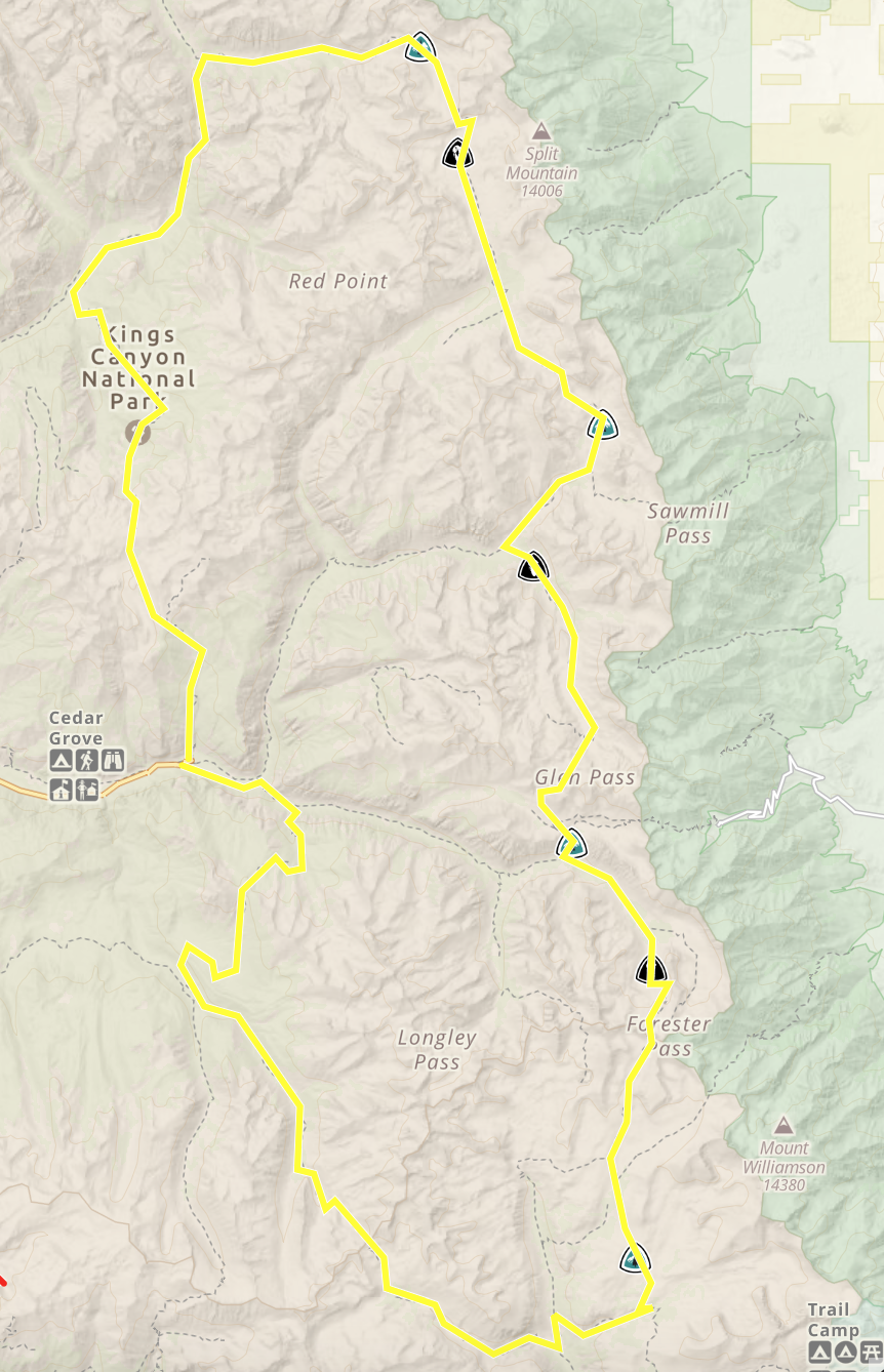
Taboose Pass - Bishop Pass Point-to-Point
Kings Canyon National Park & Inyo National Forest
While point-to-point hikes can be a headache on the logistical end, Taboose Pass is not a super popular permit entry point, and it might be worth the hassle to see some of the finest and most remote parts of the John Muir Trail.
Route Overview
Length: 42 miles (minimum)
Time: 4-7 days
Entry Trailhead: Taboose Pass (JM27)
Exit Trailhead: Bishop Pass - South Lake (JM21)
JMT Miles: 21.5
Permits: Click Here
Highlights: Dusy Basin, Palisades Lakes, Mather Pass, Upper Basin, Bench Lake
Make it Longer: Take a detour to Bench Lake right after joining the JMT, and be sure to explore the lakes in Dusy Basin.
Expert Status: The old, decommissioned JMT is a cross-country route over Cartridge Pass and into the Lake Basin. If you’re up for the Class 3-4 challenge, and want to experience a bit of history too, this route is for you! If you’ll stay on the JMT, try bagging Split Mountain, a 14er to the east of Upper Basin.

Views of Upper Basin from Mather Pass.
John Muir Trail Section
Joining the JMT at the Taboose Pass junction, you’ll travel north, switchbacking down to the South Fork of the Kings River, which can be a tricky creek crossing in high water years. After the creek, the trail gradually ascends into Upper Basin, a beautiful area with plenty of tarns, until the base of Mather Pass, where the steep switchbacks up the mountainside begin. From Mather Pass, the trail descends down rocky switchbacks into alpine meadows and down to Palisade Lakes. After the Palisades, the trail continues to descend, rather steeply down the Golden Staircase, an infamous trail design with many granite steps. Once the grade peters out, the trail becomes more gentle through Grouse Meadows until the LeConte Ranger Station, where the Bishop Pass trail picks up.

Rae Lakes Loop
Kings Canyon National Park
The Rae Lakes Loop is one of the most popular multi-night backpacking trips in the whole Sierra Nevada Range. And for good reason. Not only is the John Muir Trail super gorgeous on this loop, but the other portions of trail, including the Bubbs Creek area are lush and beautiful, and there is a high likelihood of wildlife (bear!) sightings.
Route Overview
Length: 40 miles (minimum)
Time: 3-5 days
Entry Trailhead: Woods Creek or Bubbs Creek
Exit Trailhead: Bubbs Creek or Woods Creek (opposite of entry)
JMT Miles: 12.5
Permits: Click Here
Highlights: Rae Lakes, Glen Pass
Make it Longer: Be sure to add on a side trip into the Sixty Lakes Basin. This is a great extra day on the loop, leaving a base camp at Rae Lakes. You could also add on a trip to Bullfrog and Kearsarge Lakes, and even Kearsarge Pass.
Expert Status: Gardinier Basin is another lake basin just to the west of Sixty Lakes Basin. It requires cross-country travel to access, and you could bypass Glen Pass by way of Gardinier Pass to Charlotte Lake.
Tips: The Rae Lakes Loop is a super popular trip. For the best chance of getting permits, try to go mid-week or after Labor Day.
Click here to read my trip guide for Rae Lakes!
John Muir Trail Section
Starting from the Woods Creek Suspension Bridge, you’ll gradually climb up to Dollar Lake. This area is decently exposed with few water sources. Keep looking behind you at the mountains as you climb higher! Once you reach Dollar Lake, the climb becomes even more gradual and you’ll have great views of many lakes: Arrowhead, and then the three Rae Lakes. Camping areas are the most popular at Rae Lakes, especially Middle Rae Lake. Once you pass between Upper and Middle Rae Lake, the trail steeply climbs towards Glen Pass. Enjoy the views of the unnamed tarns behind you during the final push to the top. The trail descends past beautiful pothole lakes and then down to Vidette Meadow, with view of the beautiful East Vidette and distant peaks.

Middle Rae Lake, the Painted Lady, Mount Rixford, and Glen Pass as viewed going southbound on the JMT.
Kearsarge Pass - Whitney Portal
Inyo National Forest & Sequoia & Kings Canyon National Parks
Kearsarge Pass is a pretty popular pass to enter the John Muir Trail corridor, and is also used as a resupply point for PCT and JMT hikers. It is one of the shortest trails to get to the JMT, and one of the most beautiful. It can be difficult to win a permit for Kearsarge Pass, so make sure you get your dates all figured out and reserved as early as possible! Getting an exit permit for Whitney Portal can also be a bit of a challenge. If there are no more exit permits, exit a little further south at Cottonwood Lakes!
Route Overview
Length: 48.5 miles (minimum)
Time: 3-5 days
Entry Trailhead: Kearsarge Pass (JM31)
Exit Trailhead: Whitney Portal
JMT Miles: 31
Permits: Click Here
Highlights: Kearsarge Pass, Bubbs Creek, Forester Pass, Bighorn Plateau, Guitar Lake, Mount Whitney summit.
Make it Longer: Detours to Kearsarge Lakes and Charlotte Lake can add more nights to your trip. If you want the best views of the Kearsarge Lakes, take the higher trail on the way down from Kearsarge Pass.
Expert Status: There are lots of cross-country opportunities on this section hike! First, Center Basin to Junction Pass used to be part of the JMT before it was rerouted to Forester Pass. And if you are looking to explore some remote tarns, the areas around Lake South America, Wright Lakes, and Wallace Lake will make you feel like you are worlds away from the bustle of the John Muir Trail.

Looking back down at the Bubbs Creek drainage while climbing up to Forester Pass.
John Muir Trail Section
Leaving the Kearsarge Pass trail, the JMT begins switchbacks down to Vidette Meadow, in a nicely shaded area. Once in the meadow, where there are plenty of campsites, the trail gradually ascends along Bubbs Creek for a few miles. When the mountains start getting bigger, the views open up and the trail gets steeper on the way to Forester Pass. After cresting the pass, the trail drops into a rocky basin with a few lakes. It is almost desolate, but still remarkably beautiful. The descent is gradual, down to a few creeks, Bighorn Plateau, and more wooded drainages. Once at Crabtree Meadow, the JMT enters the Whitney Zone, climbing up to Guitar Lakes, and eventually, Mt. Whitney!

Cottonwood Lakes - Whitney Portal
Inyo National Forest & Sequoia National Park
Route Overview
Length: 40 miles (minimum)
Time: 3-5 days
Entry Trailhead: Cottonwood Lakes (JM39)
Exit Trailhead: Whitney Portal
JMT Miles: 8
Permits: Click Here
Highlights: Cottonwood Lakes, New Army Pass, Guitar Lakes, Mt. Whitney
Make it Longer: You could spend many days exploring the multiple Cottonwood Lakes in the area! You also have the option of starting at the Cottonwood Pass trailhead for a longer hike, passing Chicken Spring Lake, and hiking more miles of the Pacific Crest Trail.
Expert Status: Add on a summit of Mt. Langley, and you can bag two 14ers in one trip! There are also options to go cross-country up the Rock Creek drainage towards The Miter.
John Muir Trail Section
The JMT starts at Crabtree Meadows, where there are many large camping areas, and a backcountry ranger station. You may also find a large bucket with new WAG bags if you need it. The trail climbs up through the meadows to Timberline Lake, where camping is prohibited. As the trail ascends through a mostly exposed landscape, you’ll have stunning views of Mt. Whitney from the backside and Mt. Hitchcock. Eventually, you’ll end up at Guitar Lake, where there is lots of camping, and a nice spot to camp before a Mt. Whitney summit. As you climb the trail, there are more camping areas by the small tarns above Guitar Lake as well. Once you pass these tarns, the switchbacks start up to Trail Crest. Once at the Trail Crest junction, the trail steadily climbs the final 2 miles until the Mt. Whitney summit and the southern terminus of the JMT.


Tarn above Guitar Lake at sunset.
Big SEKI Loop
Sequoia & Kings Canyon National Parks
The Big SEKI Loop is what it sounds like - a pretty big loop within Sequoia-Kings Canyon National Parks. It is a thru-hike in it’s own right - on par mileage-wise with the Tahoe Rim Trail - and just so happens to coincide with about 25% of the John Muir Trail. If you are not lucky with the JMT permit lotteries, or like the idea of a loop hike, or want to explore some more terrain off the “Sierra Highway”, the Big SEKI Loop sounds just up your alley!
Route Overview
Length: 121-155 miles
Time: 7-15 days
Entry Trailhead: Copper Creek or Bubbs Creek
Exit Trailhead: Copper Creek of Bubbs Creek (opposite of entry)
JMT Miles: 57
Permits: Click here
Highlights: The Golden Staircase, Mather Pass, Pinchot Pass, Glen Pass, Rae Lakes, Forester Pass
Alternates: There are two routes on the southern end of the loop. The main route takes the High Sierra Trail south from Junction Meadow over Kaweah Gap and to Bearpaw Camp, then over Elizabeth Pass. The Colby Pass alternate leaves Junction Meadow and travels over Colby Pass, meeting the “main route” at Roaring River Ranger Station. The Colby alternate is less miles, and if you have already done the High Sierra Trail, gives you new terrain to cover. Go the main route though, if you haven’t experienced the HST.
For a great Big SEKI Loop resource, click here.

Beautiful views from Pinchot Pass, part of the Big SEKI Loop & JMT.
John Muir Trail Section
Going counterclockwise, the JMT begins at the bottom of Grouse Meadows, at the intersection of the Middle Fork of the Kings River and Palisade Creek. The trail immediately begins climbing up towards the Golden Staircase, Palisades Lakes, and then Mather Pass. It then dips down to the South Fork of the Kings River, before again climbing up to Lake Marjorie and Pinchot Pass. The trail continues this up and down route to Woods Creek, Glen Pass, Vidette Meadow, and Forester Pass, and finally dropping down to Wallace Creek, where you leave the JMT and continue down to Junction Meadow.
There are so many different combinations of passes and trails that you could take to experience the John Muir Trail! Hopefully this gets your mind churning and maybe you’ll be able to piece together your own awesome JMT section hike!